World Models · Video Generation · Robotics
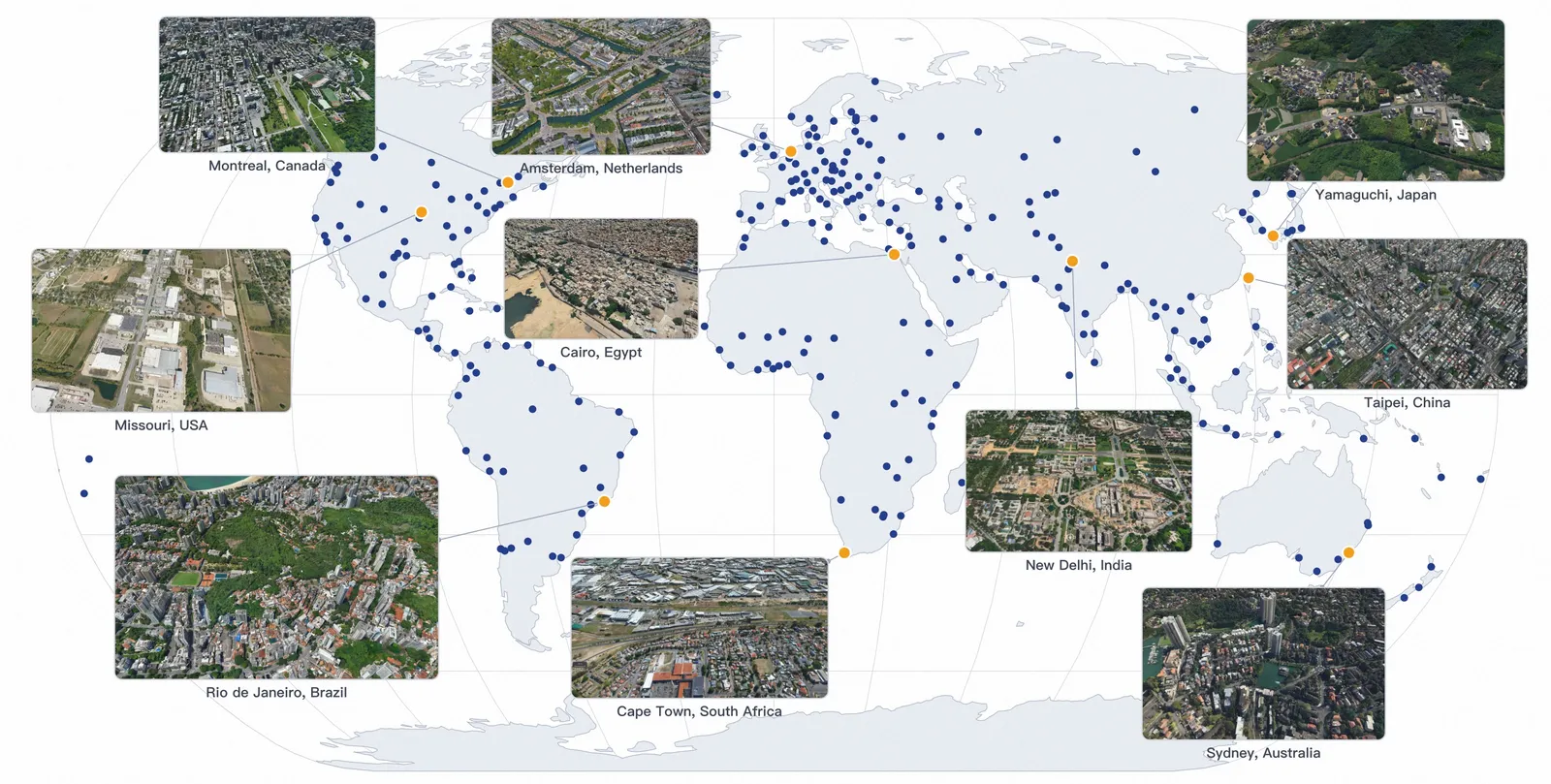
ABot-Earth 0.5: Generating 3D Cities From Satellite Images
ABot-Earth 0.5 uses satellite imagery to generate 3D Gaussian Splatting city scenes, reporting under 10 minutes per square kilometer and FID 16.1.
Quick answer
ABot-Earth 0.5 is a generative 3D Earth model from AMAP CV Lab. It takes georeferenced satellite imagery as the conditioning signal and generates large 3D Gaussian Splatting scenes for city-scale visualization. The paper reports under 10 minutes per square kilometer, FID 16.1 on its image comparison, and an official launch spanning more than 300 cities across 190 plus countries. The result is not a Google Earth replacement, but it is a strong signal that learned 3D generation is moving toward geospatial-scale scenes.
What problem it attacks
Traditional 3D city reconstruction depends on aerial surveys, dense photogrammetry, LiDAR, and heavy manual or computational post-processing. That can produce accurate geometry, but updates are slow and expensive. ABot-Earth tries the opposite route: learn a generative prior from real-world 3D reconstructions, then synthesize plausible 3DGS scenes from widely available satellite imagery.
The important word is plausible. The model is not measuring every facade or road edge directly. It predicts a realistic 3D environment conditioned on overhead imagery. That makes it useful for fast visualization, simulation backdrops, broad coverage, and early prototyping, but weaker than reconstruction when exact local geometry matters.
How the system works
The pipeline starts from multi-source imagery and real-world reconstructions, including satellite, aerial, and ground-level data. The system trains on real captures rather than purely synthetic virtual assets. During inference, the training set is organized as 200 m by 200 m tiles with overlaps for boundary context, while the production pipeline can process 4K satellite images as larger generation blocks before reorganizing them into web-map tiles.
The output is organized for web-scale viewing. Hierarchical level of detail is built into generation rather than added only as post-processing. The deployment stack reorganizes Gaussians into a six-level LOD hierarchy, uses close-view high-precision tiles and distant coarse tiles, and streams them through a map engine. The production argument is as important as the model: a planetary-scale 3D generator is only useful if the resulting assets can stream and display interactively.
Key results
- Generation speed: the paper reports 1 square kilometer generated in under 10 minutes from satellite imagery.
- Product scale: the launch presents an evolving 3DGS world across over 300 cities and more than 190 countries.
- FID and KID: ABot-Earth reports FID 16.1 and KID 0.006. The comparison table lists CityDreamer at FID 97.3/KID 0.096, GaussianCity at 86.9/0.090, and EarthCrafter at 69.5/0.061, but the paper notes that GT sets and viewpoints differ.
- Coverage: the Google Earth comparison shows regions where Google Earth has high-quality 3D in surveyed metro areas and falls back to flatter imagery elsewhere, while ABot-Earth can synthesize plausible 3D in under-covered regions such as the Ireland example.
- Human study: ABot-Earth is rated higher on aesthetics, which the authors attribute to plausible lighting and color harmony; Google Earth keeps advantages in geometry and texture fidelity.
The honest reading of the Google Earth comparison
The Google Earth comparison is useful but easy to overstate. ABot-Earth can cover more places quickly because it generates plausible 3D from satellite imagery. Google Earth is stronger where it has optimized capture and reconstruction pipelines, especially geometry and texture detail. The paper’s own comparison splits those axes: ABot-Earth wins the coverage and aesthetics story, while Google Earth remains better when the question is measured geometry or facade texture.
So the tradeoff is not “ABot beats Google Earth.” It is speed and coverage versus measured reconstruction fidelity. For robotics simulation, disaster-response previews, games, or map visualization in under-modeled areas, plausible 3D may be enough. For engineering, surveying, or legal boundary work, it is not.
Limits and open questions
The FID number is not a clean apples-to-apples benchmark. The paper itself notes that baselines use different ground-truth sets and viewpoints, so FID 16.1 versus 69.5 or 97.3 is evidence of strong visual fidelity in the authors’ setup, not a universal ranking of all 3D Earth systems.
The second limit is physical correctness. A generated city can look right while misplacing details that matter for navigation, safety, or planning. The model is valuable where fast plausible context is acceptable. It needs extra verification where exact geometry is the product.
FAQ
What is ABot-Earth 0.5?
ABot-Earth 0.5 is a generative 3D Earth model from AMAP CV Lab. It creates 3D Gaussian Splatting city scenes from georeferenced satellite imagery.
How fast is ABot-Earth 0.5?
The paper reports that ABot-Earth 0.5 can generate 1 square kilometer in under 10 minutes, using satellite imagery as input.
How does ABot-Earth 0.5 compare with Google Earth?
ABot-Earth emphasizes fast generation and broad coverage. Google Earth remains stronger in geometric and texture fidelity where it has high-quality reconstruction data and mature processing pipelines.
How fair is the ABot-Earth FID 16.1 comparison?
It is useful but not fully apples-to-apples. ABot-Earth reports FID 16.1 and KID 0.006, while CityDreamer, GaussianCity, and EarthCrafter are much worse in the table, but the paper says their GT sets and viewpoints differ.
What does ABot-Earth prove beyond rendering quality?
It proves that a tile-based 3DGS generator can be packaged for large-scale, multi-LOD map browsing. It does not prove survey-grade geometry or safety-critical localization accuracy.
What is the main limitation of ABot-Earth 0.5?
It generates plausible 3D scenes rather than exact surveyed geometry. That is useful for visualization and simulation backdrops, but risky for applications that require precise physical measurement.
One line: ABot-Earth 0.5 matters because it treats 3D Earth coverage as a generative modeling problem, not only a photogrammetry pipeline. Read the original paper on arXiv.